Interlinking of Rivers in India – An Ambitious Project
Published on by Aniruddh Gupta in Government
The National River Linking Project (NRLP) was mooted by the Vajpayee government in 2002 to artificially link 14 Himalayan rivers in northern India and 16 peninsular rivers in southern India.
 Initially it was started at Rs 5.6 lakh crore at 2002-03 prices, however as of now the estimated cost is around Rs. 11 lakh crore. This includes the cost of land acquisition, compensation and construction.
Water is a scarce commodity and several basins such as Cauvery, Yamuna, Sutlej, Ravi and other smaller inter-state/intra-state rivers are short of water. 99 districts of the country are classified as drought prone and an area of about 40 million hectares is prone to recurring floods.
The inter-link project is expected to help reduce the scale of this suffering and associated losses.
India approved and commissioned the NDWA in June, 2005 to identify and complete feasibility studies of intra-state projects that would inter-link rivers within that state.
The governments of Nagaland, Meghalaya, Kerala, Punjab, Delhi, Sikkim, Haryana and the Union Territories of Puducherry, Andaman & Nicobar, Daman & Diu and Lakshadweep responded that they have no intra-state river connecting proposals. Tehe govt. of Puducherry proposed the Pennaiyar – Sankarabarani link (even though it is not an intra-state project).
The states government of Bihar proposed 6 inter-linking projects, Maharashtra 20 projects, Gujarat 1 project, Orissa 3 projects, Rajasthan 2 projects, Jharkhand 3 projects and Tamil Nadu 1 inter-linking proposal between rivers inside their respective territories. In 2005, the NDWA completed feasibility studies on the projects and found 1 project infeasible, 20 projects feasible and 1 project was withdrawn by the government of Maharashtra while others are still under study.
The overall implementation of the Interlinking of Rivers programme under the National Perspective Plan would give benefits of 35 million hectares of irrigation, raising the ultimate irrigation potential from 140 million hectares to 175 million hectares and generation of 34,000 megawatts of power, apart from the incidental benefits of flood control, navigation, water supply, fisheries, salinity and pollution control etc.
The National Perspective Plan comprised, starting in the 1980s, of two main components: Himalayan Rivers Development, and Peninsular Rivers Development. However, an intra-state component was added in 2005.
The Himalayan component would consist of a series of dams built along the Ganga and Brahmaputra rivers in India, Nepal and Bhutan for storage. Canals would be built to transfer surplus water from the eastern tributaries of the Ganga to the west.
This is expected to contribute to flood control measures in the Ganga and Brahmaputra river basins. It could also provide excess water for the Farakka Barrage to flush out the silt at the port of Kolkata.
Apart from providing irrigation to an additional area of about 22 million hectares, and the generation of about 30 million kilowatts of hydro-power, it will provide substantial flood control in the Ganga-Brahmaputra basin. The scheme will benefit not only the states in the Ganga-Brahmaputra basin, but also Nepal and Bangladesh, assuming river flow management treaties are successfully negotiated.
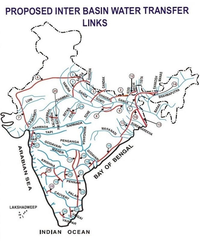
By 2015, fourteen inter-links under consideration for Himalayan component are as follows:
- Ghaghara - Yamuna link
- Sarda - Yamuna link
- Yamuna - Rajasthan link
- Rajasthan - Sabarmati link
- Kosi - Ghaghara link
- Kosi - Mechi link
- Manas - Sankosh - Tista - Ganga link
- Jogighopa - Tista - Farakka link
- Ganga - Damodar - Subernarekha link
- Subernarekha - Mahanadi link
- Farakka - Sunderbans link
- Gandak - Ganga link
- Chunar - Sone Barrage link
- Sone dam - Southern tributaries of Ganga link
|
|
River Interlinking Blue Prints of India, Source: IWMI | Proposed Inter Basin Water Transfer Links, Source: http://india-wris.nrsc.gov.in |
The Peninsular Component Scheme is divided into four major parts. This component will irrigate an additional 25 million hectares by surface water, 10 million hectares by increased use of ground water and generate hydro power, apart from the benefits of improved flood control and regional navigation.
- Interlinking of Mahanadi – Godavari – Krishna – Pennar - Cauvery
- Interlinking of west flowing rivers, north of Bombay and south of Tapi
- Inter-linking of Ken with Chambal
- Diversion of some water from west flowing rivers
Media
Taxonomy
- Water
- River Studies
- River Engineering
- Infrastructure
- Chemicals
- Consulting & Services
- Energy
- Green Technology
8 Comments
-
#ashutoshjoshi #AshutoshJoshiWakeUpIndiaMovement #mediafoundation #iyp #youthparliament #Bhartiyayuwasansad#युवासंसद #UNWorldDemocracyDay #InternationalDayofDemocracy#InternationalDemocracyDay #IndianFirst #sansad #waterparliament#watertalk #swatantratasenani #jalsamvad
indanyouthparliament.co.in
-
Scientists who love wearing the cap of environmentalists should first organise their thinking on HOW PRECIOUS LITTLE OUR GOVERNMENTS HAVE BEEN DOING FOR LIFE SUPPORT SYSTEM CALLED WATER.
Have we pushed our Government in at least 100% collection and transport of Sewerage and its effective processing at STPs? (No)
How much increase in reservoir capacity have we invested in during the period when our population has grown five folds? (We have allowed reservoirs to be dried up)
Have we prevented influence of untreated wastes getting into our river systems which sure has damaged eco balance and flora and fauna?(No)
Then why are we raising hue and cry at some judicious use opportunity of putting surplus part of surface run offs thru interlinking of rivers !
We can always insist on putting the plans to stricter technical scrutiny but why not three cheers to Government that is having some intention of spreading the surplus waters to address the questions of floods , droughts and wasteful passage of all surface waters into sea.
-
Critics can say that Bay of Bengal will get ruined with water levels falling down but most critics are just the inertia of momentum. Nothing will happen if say waters of Brahmaputra are tapped during monsoons in a major way and then tapping is tapered off to ensure adequate flow levels during lean season.
Tapping say 10% of River outflows a safe distance away from the meeting point with the sea/ocean and taking surface waters to another coastal area or even pumping up for slow release during lean periods can do wonders.. We can nor only moderate the flows of linked rivers but also feed additional capacity of storage reservoirs and recharge the ground water aquifers also. Critics can be rest assured that nature will find its own ways to stabilise positive impacts on wild life as drowning during floods will not reduce its population and additional moisture in drought areas will also have positive impacts.
1 Comment reply
-
LOKESH PUNJ There are always two sides in a coin.
-
-
This can be an ecological and socioeconomic disaster for millions of village people. The numerous negative aspects have been debated for the past 30 years. Diverting freshwaters from the Brahmaputra, for instance, will lead to reduced outflows in the Bay of Bengal, leading to accelerated salinization of coastal groundwater, seawater traveling upstream further in the dry season, siltation and reduced nutrient input into the sunder bans estuary with grave consequences for marine fisheries and the livelihoods of millions. Interlinking, and changing the natural flow regimes of rivers will affect fisheries, water quality and availability for all riverine communities. Excess irrigation can lead to salinization of inland farms, as has been happening in Punjab. A few stakeholders benefit ( power companies, construction companies. large agribusinesses ) while the rural communities and the ecosystem pays for this. Folly. In most of the developed world, such projects are being pulled out and the natural flow in rivers being restored. And in India we are still proposing Nehruvian grand solutions which have been shown to be extremely harmful.
1 Comment reply
-
Amartya Saha it is nice to see your comments however every thing has his benefits and disadvantages. It depends that how you are looking in to it.
-
-
I appreciate this project, however, the Himalayan communities must be paid back for the maintenance of these rivers and their tributaries, and biodiversity conservation up on the Himalayas that makes these rivers flawless.
1 Comment reply
-
Yashwant Rawat rightly said
-
-
Hi Anirudha Gupta ,Great you have well written.This information is great.Now we have to find out the yearly Loss due to FLOOD,and Drought.The Pain and sufferings of People.The Loss HOW MANY LAKHS CORORES.?Here after 70 years of Independence why we cant work for this great PROJECT.Now the CAUVERY issue,the Life of people,The LOSS due to Riots,The Problems with people-good neibhours became hatred-The Respected Supreme Court and the Legislative Assembly ,all are interevene. NO Remedy.WATER IS PRECIOUS THAN ANY THING.A POLITICAL WILL IS NEEDED WITH LOOSING NO TIME AND WITH IN TIME THE PROJECT SHOULD BE COMPLETED.
1 Comment reply
-
Mathai (Mathew) M.V. thanks for your words of appreciation. Your comments are 100% correct.
-
-
For the implementation of integrated effects used specifically designed for this purpose and having the appropriate certificates, the generator, which is a complex consisting of a multifunctional low-frequency generator and inverter.
Components of comprehensive water treatment.
Water treatment for the purpose of disinfection.
Disinfection of water is produced by non-contact or contact (immersion in water to be treated predbrazovatelya) processing. The goal of treatment is to eliminate the water contained in the pathogenic microflora.
Water purification from harmful elements and compounds
The processing decomposition of harmful substances, the formation of insoluble compounds and their precipitation in the sludge or release them in a gas. Thus, cleaning is made from suspended solids, ammonia nitrogen, nitrate, phosphate, etc.
Water purification from oil present therein or substances with similar properties.
Effect is produced to decompose the above substances or binding present in water. As a result, their separation and loss in the form of sludge.2 Comment replies
-
Yaroslav Gryaznov I didn't get your comments on this article.
-
We are proposing technological interventions on interception drains bringing lot of sewage water and sludge into rivers and shall appreciate if you share technical details/ any brochure/project details with me at lok.punj@gmail.com to enable us assess if we could collaborate to put your technology experience into our Pilot Project Proposal/s. We shall be using flocculation polymers to arrest the solid contaminants.
-
-
Singular authority and legal empowerment with full accountability of planning and implementation and open mind to leverage technology economically is desirable otherwise, state's PWDs dominated by civil engineers mess up the projects with time and costs over runs.. Are all technical details available and open to any improvements in planning?
1 Comment reply